Diverse and Dynamic Ecosystems
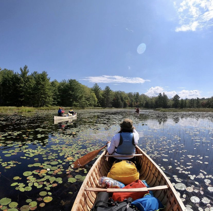
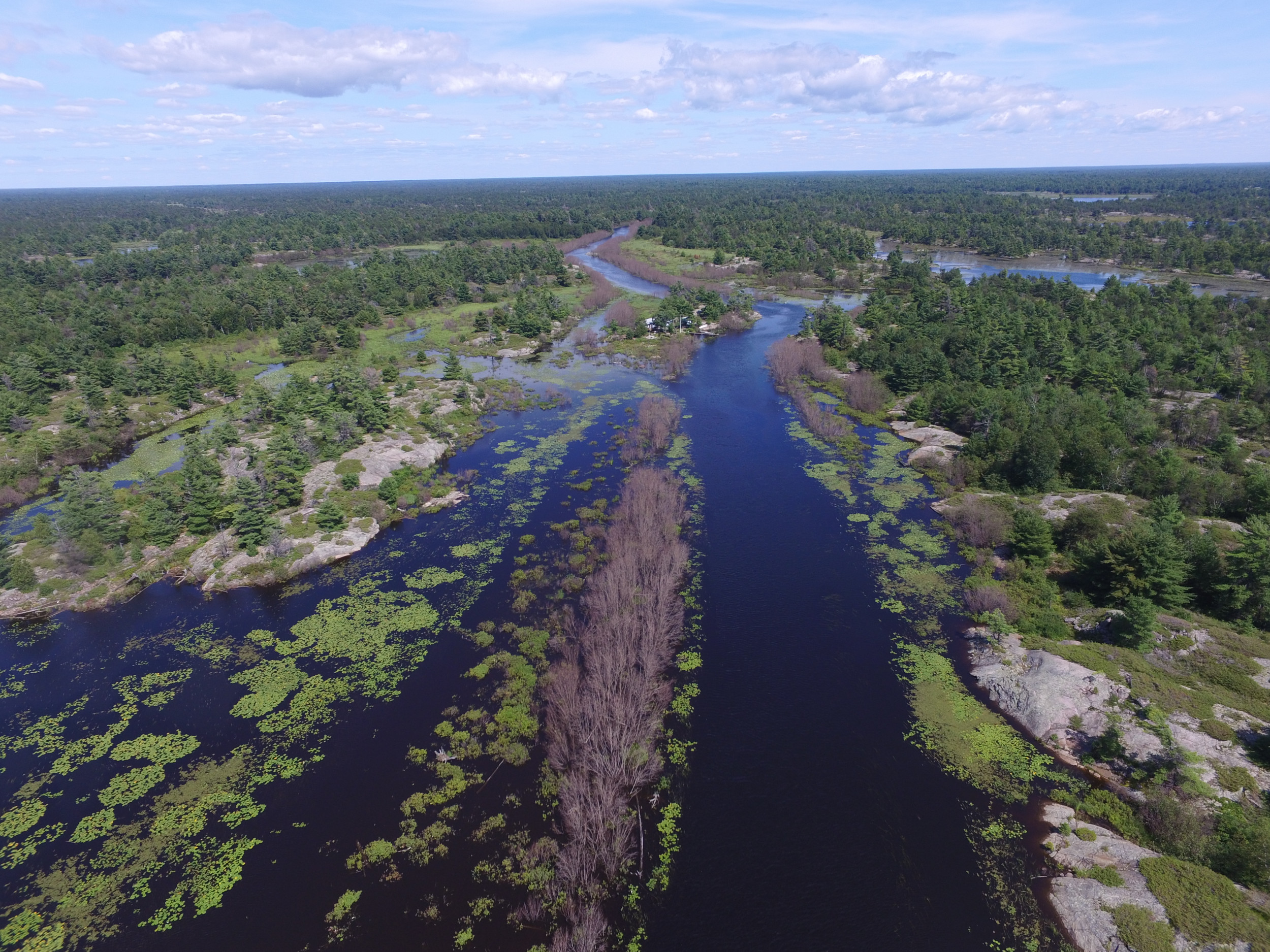
Eastern Georgian Bay is famous for its extensive collection of islands—or freshwater archipelago—with an abundance of coastal wetland habitat along its shoreline. Coastal wetlands are incredibly productive ecosystems with high ecological, cultural, and economic value. Healthy wetlands filter water, store carbon, play a role in controlling flooding,
and help mitigate more frequent extreme weather events resulting from climate change.
Wetlands support high levels of biodiversity because they are transitional environments providing habitat for both aquatic and terrestrial species, and are resilient to changes in water level. Patches of small coastal wetlands work together to provide critical habitat for spawning fish, breeding amphibians, colonies of birds, such as the great blue heron (shagi), and feeding grounds for the endangered Massasauga rattlesnake (zhiishiigweg) and eastern foxsnake.
Indigenous peoples have an inherent right to hunt, fish, and harvest plants, berries, wild rice, and other foods. Healthy wetlands help maintain cultural and spiritual relationships with plants, animals, birds, and water creatures. The gift of food from the lands and waters of Mnidoo-gamii, its rivers, forests, wetlands, and islands, are part of natural law and Anishinaabek food sovereignty.
Human activities have resulted in the loss of many Great Lakes wetlands. Coastal wetlands have been filled in, dredged up, paved over, and converted to other land uses. Invasive species, such as Phragmites australis (European common reed) have been introduced and can completely replace native vegetation, destroying wetland habitat and its ecological functions.
Fortunately, Georgian Bay still contains high-quality wetlands distributed along most of its shorelines that are relatively protected from roads and human development. However, these wetlands still face the threat of human impact from shoreline modifications, increased runoff and sediment, water withdrawals, invasive species, and the increasing impacts of climate change.
McMaster University Coastal Wetland Research Group
Since 2003, the coastal wetlands of eastern and northern Georgian Bay have been continuously studied by researchers from McMaster University’s Coastal Wetland Research Group. Led by Dr. Patricia Chow-Fraser, this research group has created one of the largest and most comprehensive databases on Georgian Bay’s coastal wetlands. Their work has focused on a broad range of topics, including the effect of changing water levels on coastal wetlands, how human activities are influencing nutrients in coastal bays, how species at risk reptiles use their habitats, and more recently how the proximity of boreal forest landscapes to water bodies and human features affects their recovery from wildfires.
Learn more about McMaster University’s Coastal Wetland Research Group.
Water Levels & Wetlands
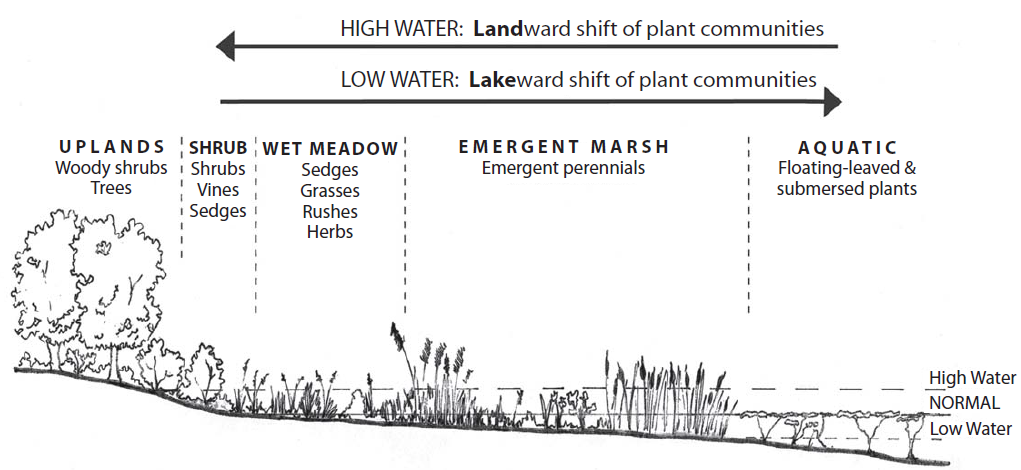
Not only are coastal wetlands important habitat for a variety of fish and wildlife, but they contain some of the highest plant diversity, too. Marshes can contain floating aquatic vegetation, submerged aquatic plants, meadow plants, and shrubs—and they may look very different from one year to the next.
One reason that coastal marshes contain so many different plants is that they are subject to changes in water levels. Periodic flooding changes the plant composition, brings in new nutrients, and can expand the total area of wetland. Periods of low water levels may support more meadow species and even the arrival of shrubs and the establishment of young trees.
The scientific term for alternating high and low water levels in wetlands is “dynamic hydrological gradient,” meaning that the vegetation zones in coastal wetlands go from fully submerged to dry upland areas. This gradient looks different depending on the slope of the shoreline and lake bottom.
It is important to recognize that lake levels naturally influence coastal wetlands, and there are species that benefit when water levels are higher and others that thrive during drier periods, when the water levels have dropped. With climate change likely to reshape water level variation into the future, researchers are trying to understand how these changes will impact wetlands in Georgian Bay and the Great Lakes more broadly.
Higher Highs and Lower Lows
The winter of 2022–2023 was one of the warmest on record. For the first time in its 52-year history, the National Capital Commission in Ottawa did not open the Rideau Canal Skateway. Lake Huron ice coverage was very low, and surface water temperature was near the highest recorded. Climate change is causing measurable impacts in the Great Lakes region related to temperature, precipitation, storms, flooding, and water levels.
Contrary to most people’s intuition, there is very little evaporation from Lake Huron on a hot summer day. Most evaporation occurs in the colder months of the year, when cold air is passing over the relatively warmer open water—much like a pot of hot water steams into the colder room-temperature air. As the water in the lake cools and ice forms over the water’s surface, evaporation slows, like putting a lid on the pot. This dynamic creates the starting conditions for the coming year’s water levels.
From annual relative lows in the winter, water levels in Lakes Michigan and Huron rise until they reach a late-summer peak. If, over several years, there is more precipitation entering the lake than evaporation leaving it, water levels rise. If the balance shifts toward more evaporation and less precipitation, water levels decline. That balance has, over the measured historic record, produced water levels that have fluctuated from the lowest to the highest level by about 1.93 metres (6.33 feet).
Climate change is throwing this historic balance off. There is more water vapour and energy in the air when it is hotter—approximately a 6% increase in vapour-carrying capacity per degree Celsius. This means that future hydrologic conditions are expected to be more variable than the historic record. It shifts the balance toward favouring precipitation over evaporation.
In reality, the thermodynamics involved are more complicated than a simple pot of boiling water. Beneath the surface of the lakes there is a huge volume of water acting as a heat sink during warm months and as a heat source during cold months. Taking this into account in new three-dimensional models, American researchers project that by 2040–2049, the average monthly water levels of Lakes Michigan and Huron will increase by 0.39 metres relative to the 2010–2019 period.
Newly released modelling by scientists at Environment and Climate Change Canada shows that over-lake precipitation and over-lake evaporation are expected to increase, expanding the water level range variability up to 0.5 metres above historical extremes under a scenario where emissions slowly decline and global temperatures increase by 2.4°C. This is an increasingly likely scenario given that in May 2022 the World Meteorological Organization stated that there was a 50/50 chance that one of the following five years would exceed 1.5°C above the pre-industrial average global temperature.

“If we do not take the threat of greenhouse gas emissions seriously and continue on the present track, it could catastrophically lead to a 4.5°C temperature increase, resulting in an even greater modelled water level range variability of roughly one metre above historical extremes.”
David Sweetnam, Georgian Bay Forever
Great Lakes water levels are anticipated to experience more variability as the climate changes, resulting in more extreme highs and lows. High GHG scenarios show the most extreme changes occurring, but actual changes in water levels will depend on actual GHG emissions and how the atmosphere responds.
A Changing Great Lakes Basin
Evidence suggests that climate change is leading towards an increase in precipitation. At the same time, climate change has also shown trends in increasing air temperatures and increasing lake temperatures across the basin, which naturally leads to higher rates of evaporation. These two processes act as competing forces on water levels. Higher precipitation and/or lower evaporation at times will lead to more water on the landscape and higher water levels, but at other times, higher evaporation and/or lower precipitation will lead to lower water levels. With these two competing dynamic forces at odds with each other, some have alluded to this as a “tug-of-war” between stronger climatic forces.
The higher water levels in the Great Lakes in 2014 was a change from record low water levels in 2012 and 2013. It was believed to be initiated by a combination of increased precipitation, but more importantly a slowdown in the rate of evaporation triggered by the very cold winter of 2014, which was caused by a polar vortex that sent cold air southward and froze the Lakes. This reduced evaporation and increased precipitation resulted in water levels that have risen in the Great Lakes to the record extremes observed in 2017 and 2019. Climate experts believe that this swing of the pendulum, going from one extreme of low water to one of high water, is in fact a consequence of climate change across the Great Lakes Basin and at continental scales.
Independent Review of the 2019 Floods in Ontario
Partner Profile: Environment and Climate Change Canada
Wetlands are known to be dynamic systems that have been resilient to changing water levels, but what is less known is how resilient they will be to changes brought on by the impacts of climate change, including varying water levels, water temperatures, precipitation, exposure to wind and wave action, and invasive species.
Environment and Climate Change Canada conducted an extensive study on coastal wetlands in the Great Lakes to determine their vulnerability, sensitivity, and capacity to adapt to climate change. Of the 20 coastal wetlands in the study, three were in eastern Georgian Bay:
- Treasure Bay, on Beausoleil Island, within Georgian Bay Islands National Park
- Hog Bay, a provincially significant wetland in Severn Sound
- Frances Point, on the northeastern tip of Franklin Island, near Brooks Landing
Researchers assessed each of the wetlands in the study under a low- and high-water scenario, as well as against multiple other factors related to climate impacts to help determine their level of vulnerability. In general, the modelling showed that wetlands in eastern Georgian Bay showed greater vulnerability to the effects of climate change under higher water levels when compared to the same wetlands under more stable or lower water levels.
Learn more about the study.
Partner Profile: Georgian Bay Forever
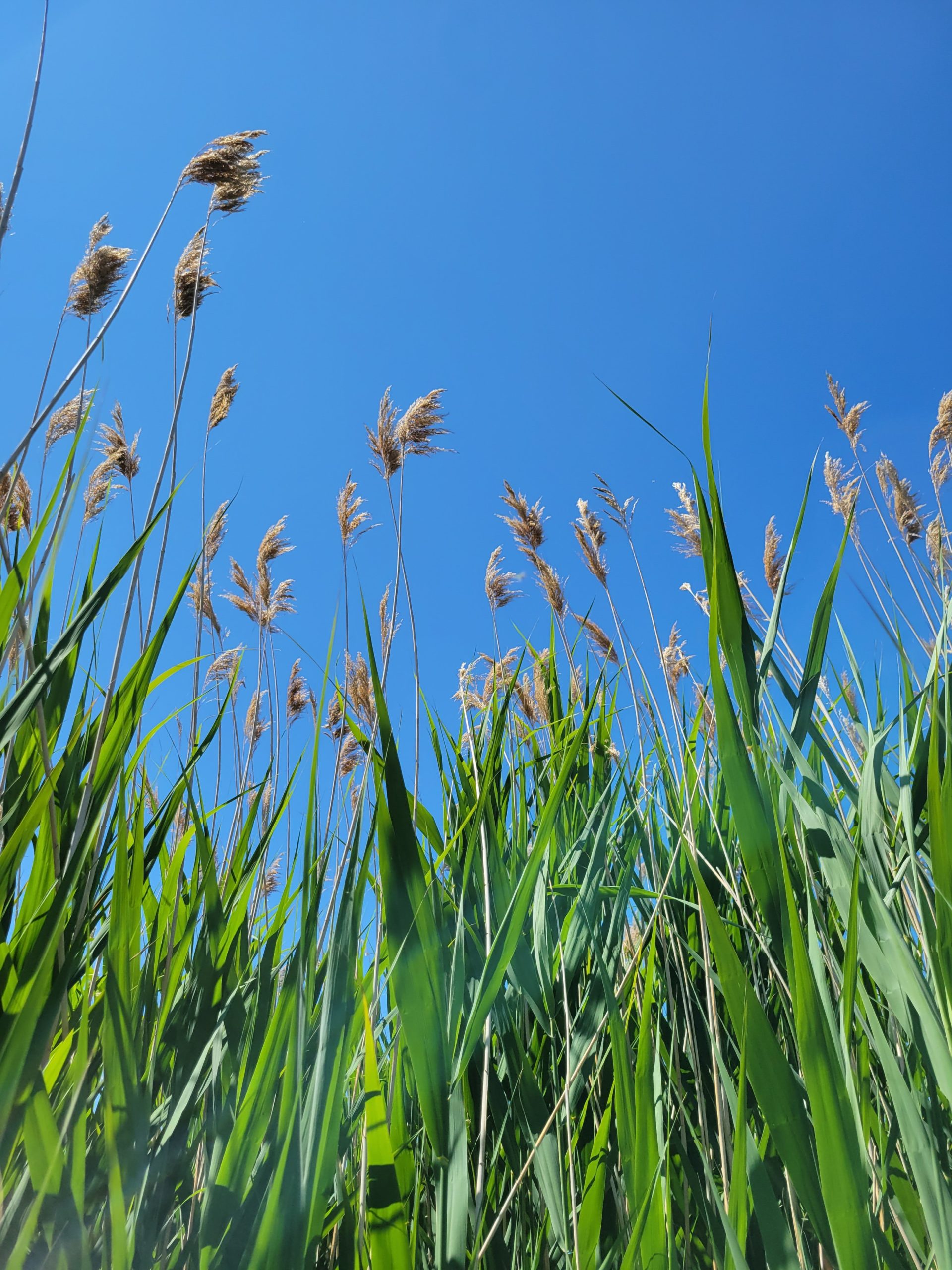
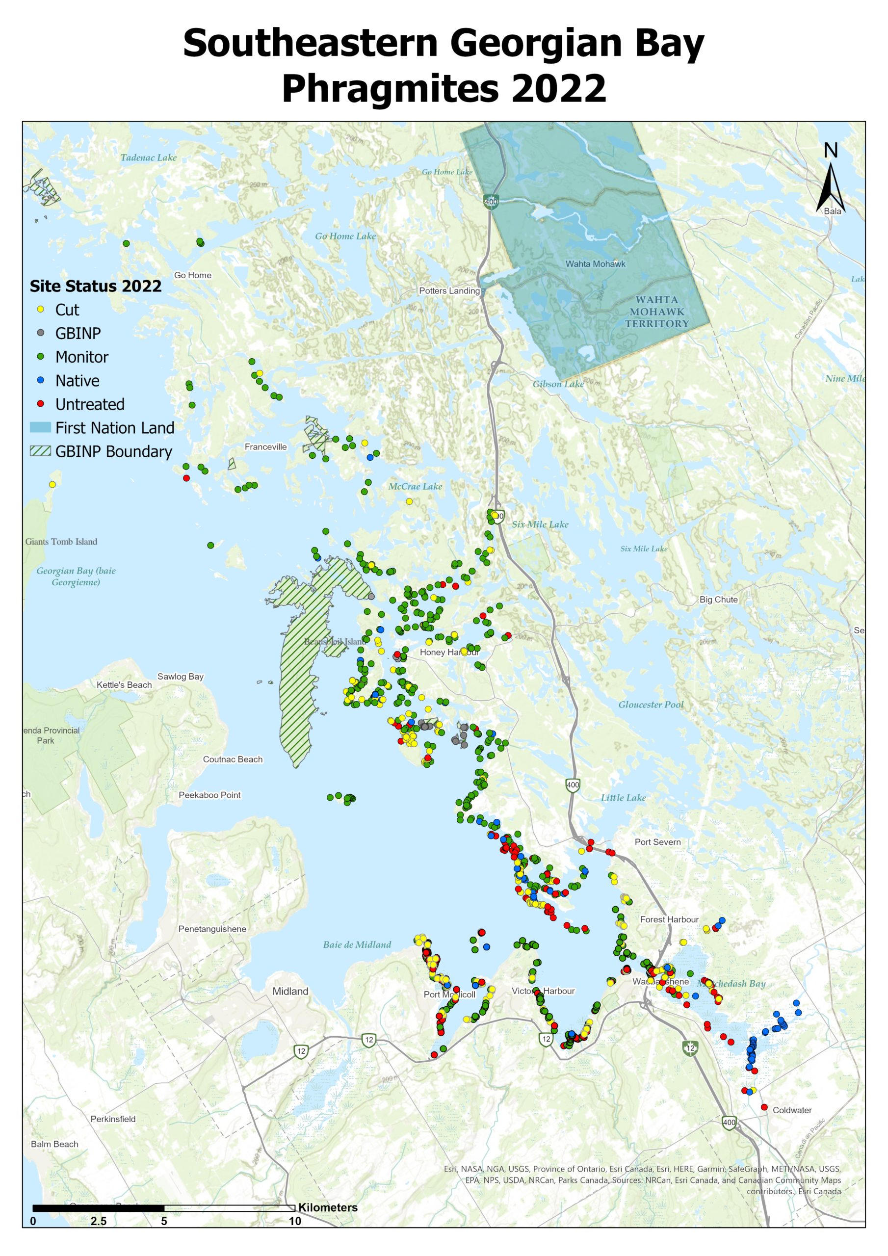
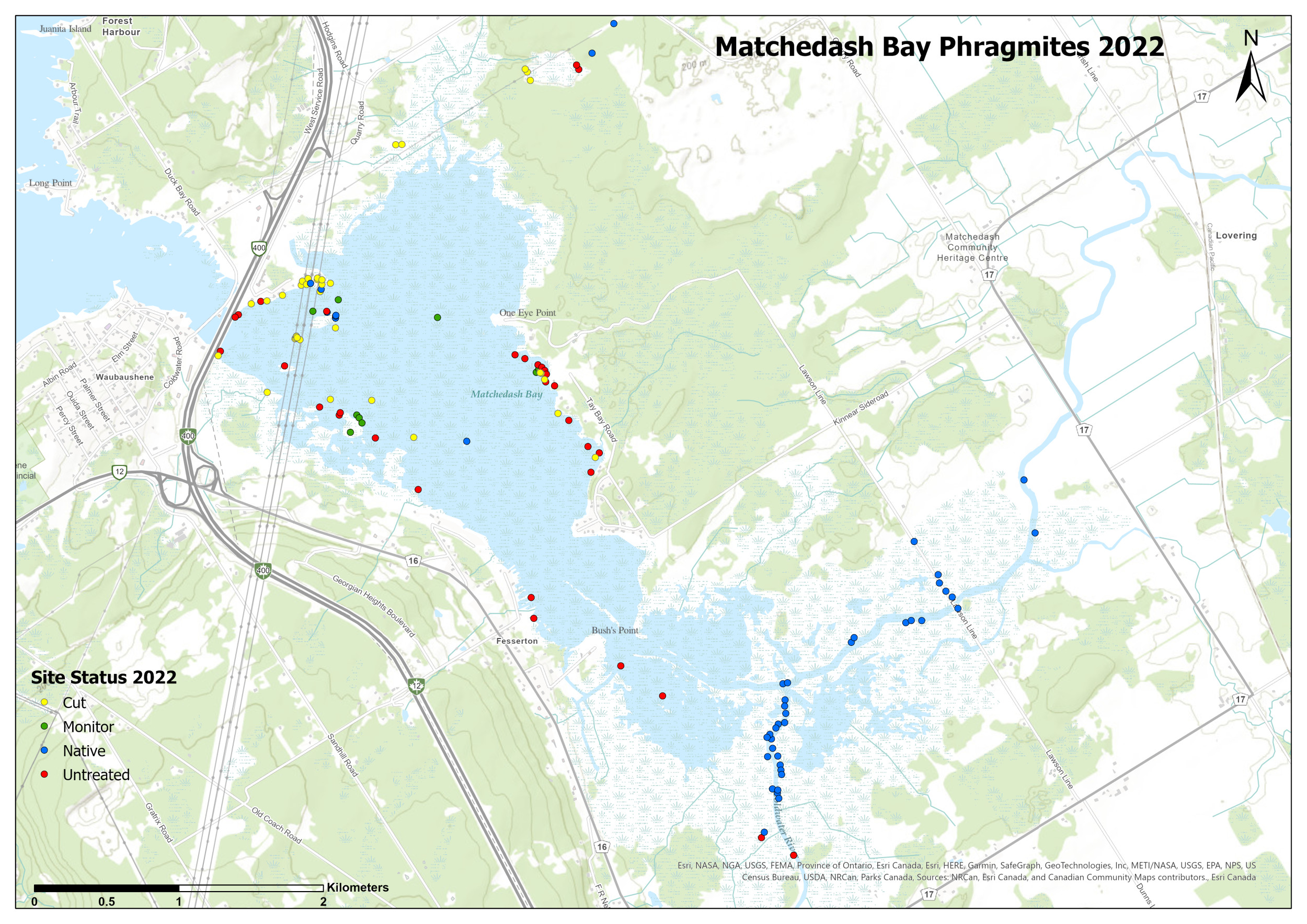
Phragmites australis, or the European common reed, is an invasive plant that has colonized much of the Great Lakes region, with devastating effects. It can be seen lining highways, filling ditches, and expanding through wetlands and waterways. Phragmites is one of the most damaging invasive plant species in Canada, and not a problem that will go away on its own.
Since the first known North American documentation of Phragmites in the early 20th century, this plant has been progressively taking over the shores of natural bodies of water, including Georgian Bay. While it may look relatively harmless—a perpetrator hiding in plain sight—it constitutes an immediate and severe threat to our ecosystem.
Phragmites grows aggressively and spreads quickly, dominating the areas in which it grows by releasing toxins from its root system, effectively depleting and damaging food sources for native plants.
The dense structure of a Phragmites stand also creates an inhospitable environment for local wildlife, with fish and turtles dying after becoming trapped in the plant’s dense stalks. Over time, biodiversity suffers due to the choking out of native plant life, which usually provides a safe habitat for wetland animals. The plant’s height (up to 5.5 metres tall) impedes land animals from accessing the water and can also affect people’s ability to enjoy activities such as swimming and boating. Additionally, the mass amounts of tall grass contribute to low water levels and increase the risk of wildfires, further adding to the strain on the local ecosystem.
Addressing the Problem
Georgian Bay Forever is committed to tackling the Phragmites invasion with non-chemical and carefully planned long-term management strategies. The most effective way to remove Phragmites stands without herbicides is to create an ongoing cycle of stressors to the root system, monitor the cut base for regrowth, and remove cut stalks from the water in which they may regenerate roots.
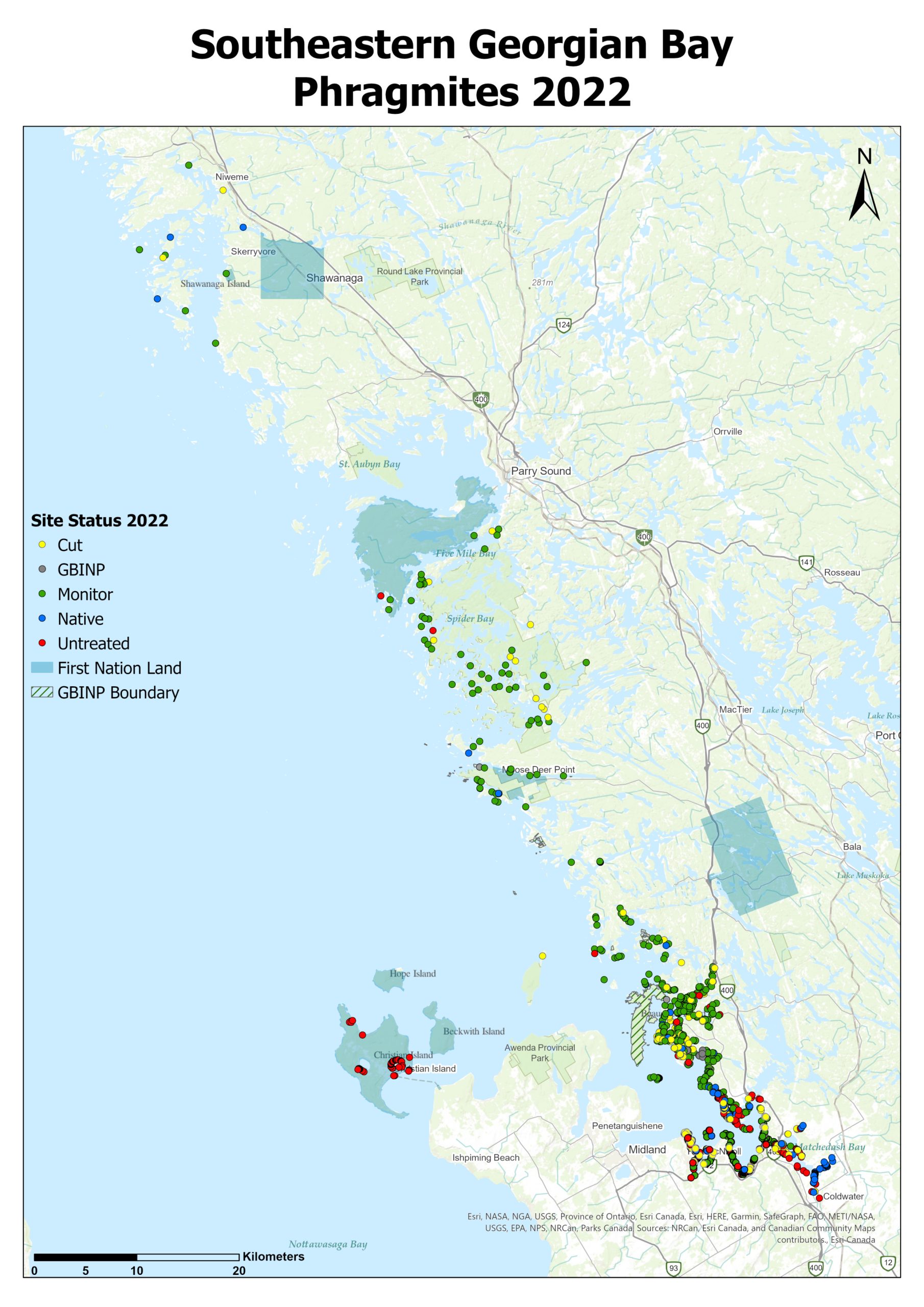
By the summer of 2022, Georgian Bay Forever had mapped 962 Phragmites stands, eradicated (with ongoing monitoring) 509 stands, and was in the process of cutting an additional 255 stands. Together, these remediation efforts represented approximately 80% of mapped stands under control in Georgian Bay.
“The work is laborious and demanding of both resources and commitment, but the rewards are worth it for the health and longevity of Georgian Bay” says Laura Thipphawong of Georgian Bay Forever.
Learn more about Georgian Bay Forever.
Seven Steps to Controlling Invasive Phragmites on Shorelines and Wetlands
1. Identify and Map
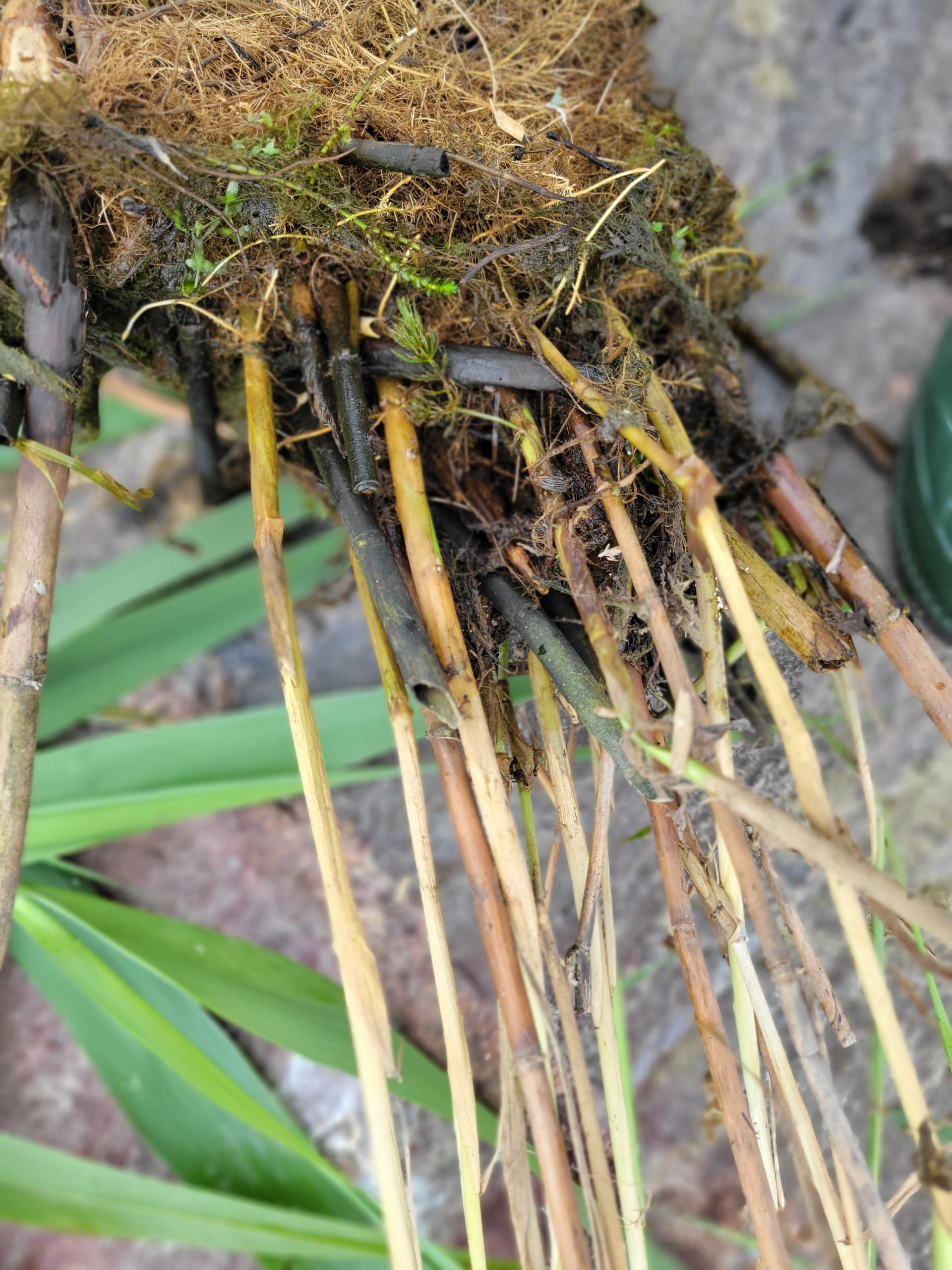
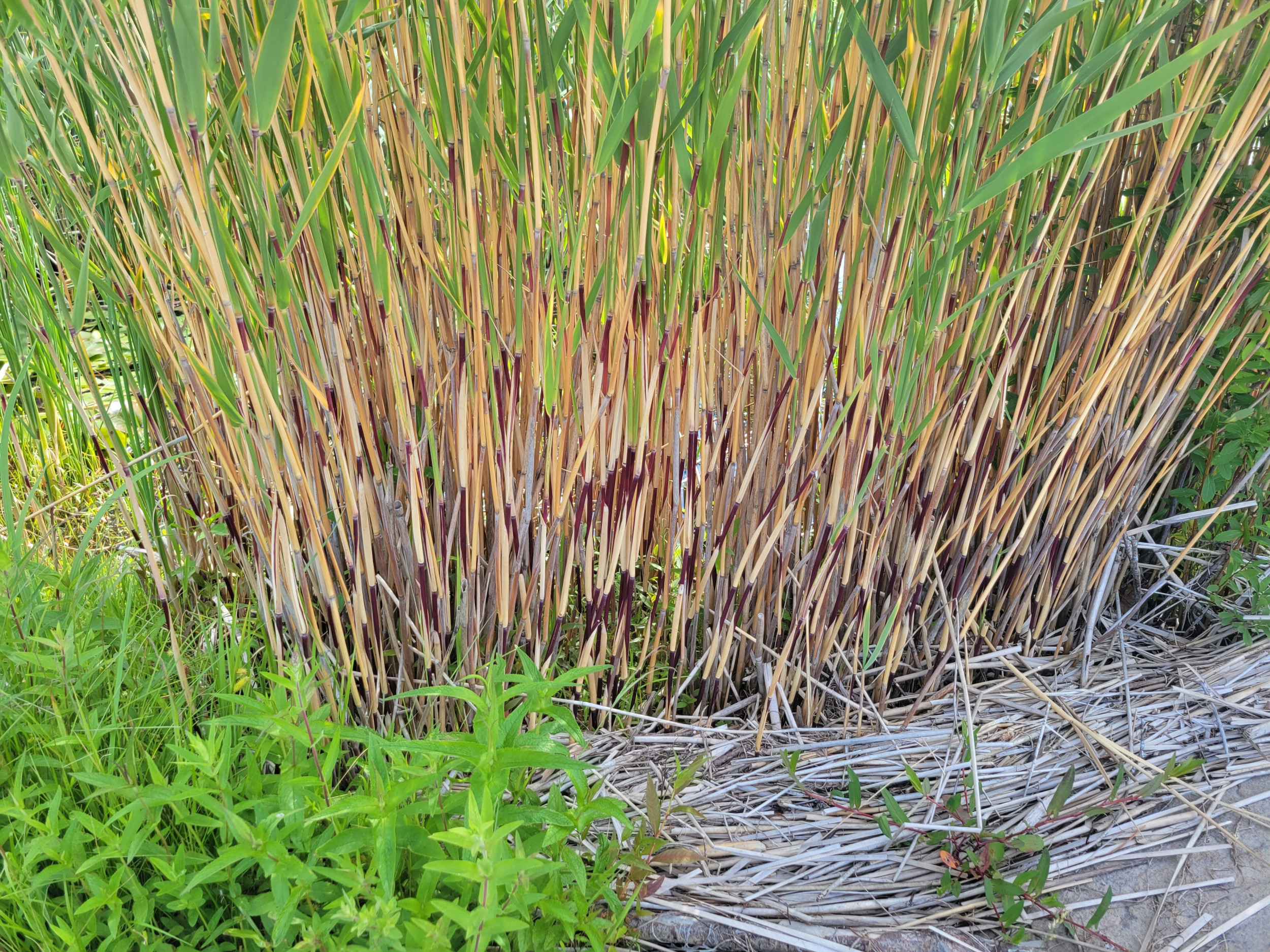
Be sure to identify whether the plant is native or invasive, and record the size and location of the site for future reference. One obvious difference is seen at the base of the stalks in mature stands. Invasive Phragmites feel rough and are beige, while native Phragmites feel smooth and have strong red colouring on the stalks.
2. Create a Community Group
Create a working group or network of landowners that could act as a Phragmites resource committee for other landowners in the area. This network can also keep everyone alert to any new or existing Phragmites stands.
3. Gather Equipment
This could include hand-held cutters, rubber boots, gardening gloves, eye protection, hat, PFD, natural twine, yard-waste or garbage bags, transportation for disposal (such as a sleigh or wheelbarrow and perhaps a tarp to cover the cut Phragmites) and anything else you may need when working outdoors.
4. Timing
Remove the stalks between mid-July and mid-August, before seedheads emerge from late August to October. (Note that native Phragmites seedheads emerge earlier in the season, around mid-July).
5. Cutting
If there are seedheads, remove them first and put them into yard-waste bags to rot out and die. Next, begin cutting on the outside of the patch and work inward. Cut each stalk underwater as close as safely possible to the sediment (not just below the surface). Be sure to only remove the stalks and attached leaves. Do not try to disturb or remove the roots; they are extensive and uprooting them can contribute to the spread.
6. Disposal
Collect all cut biomass and floating debris. Find a designated spot nearby where cut stalks can dry out and decay. You want to choose somewhere far enough away that rising water levels and wind and wave action will not pull it back in. You can use twine to wrap up the material for easier transport and disposal.
7. Follow-Up
The next year, check the disposal site to ensure nothing has sprouted from the piles. Also, check the cutting site for any regrowth and make plans to cut again. It can take two to seven years of repetitive removal to eradicate a stand.
Reprinted from georgianbayforever.org, with permission.
How You Can Help: Track Invasive Species
Invasive species are spreading quickly, and you can report their location (including insects, plants, and aquatic species) using the Early Detection and Distribution Mapping System (or EDDMapS). You can submit invasive species sightings using either a smartphone or a computer. Sightings are then uploaded to EDDMapS and emailed directly to reviewers to confirm. The maps and information are freely available to scientists, resource managers, and the public. Having good data on the locations of invasive species improves our ability to manage and respond to them.
Learn more at eddmaps.org.